Manor of Plardiwick
People may not realise that there is still a Lord of the Manor of Plardiwick in the civil parish of Gnosall.
The
person
holding
this
title
is
Ronald
Smith.
He
and
his
late
wife
Margaret
purchased
the
title
at
an
auction
sale
of
36
Lordships
in
London
in
1987.
It
is
a
'paper
title',
which
means
that
the
title
has
no
land
attached
to
it,
but
the
title
can
be used by the person, for example on bank cheques. Some Lordships do have rights attached to them.
When
they
bought
the
title,
the
Smiths
knew
nothing
about
Plardiwick,
but
they
did
a
lot
of
research
into
its
history.
For
example
they
discovered
that
in
1415
the
King,
Henry
V,
on
closing
alien
houses,
redistributed
their
lands
and
gave
Plardiwick, among others, to the Carthusian Priory at Shene, Richmond.
Ronald
Smith
was
Chairman
of
the
London
Green
Belt
Council
for
25
years
and
at
the
time
of
writing
is
a
Vice-
President
of
the
Open
Spaces
Society
and
therefore
has
an
interest
in
commons.
That
is
how
I
came
to
get
to
know
him
and
his
wife
in
the
1980s.
Ronald
registered
an
interest
on
the
Commons
Register
in
any
individual
rights
he
might
have
had
in
Doley
Common.
However,
Staffordshire
County
Council
refused
the
registration
on
the
grounds
that
the Common no longer forms part of the manor, nor does the manor still exist.
Margaret and Ronald found sixteen spellings of the name:
There are no doubt others to be found.
Mary Booth - 2020
Lord of the Manor of Plardiwick
"I
had
always
wanted
to
take
an
apparently
insignificant
bit
of
England
and
see
what
could
be
unearthed
about
it...and
nothing
could
be
more
inconspicuous
than
Plardiwick,"
are
the
words
written
by
Ronald
Smith
in
explanation
of
his
decision
to
purchase
the
Lordship
of
the
Manor
in
1986.
Documents
held
by
the
Stafford
Record
Office
and
William
Salt
Library
and
referenced
by
Mr
Smith
in
conjunction
with
'The
Victoria
County
History
of
Staffordshire'
and
other
sources have been used in part to write this brief history.
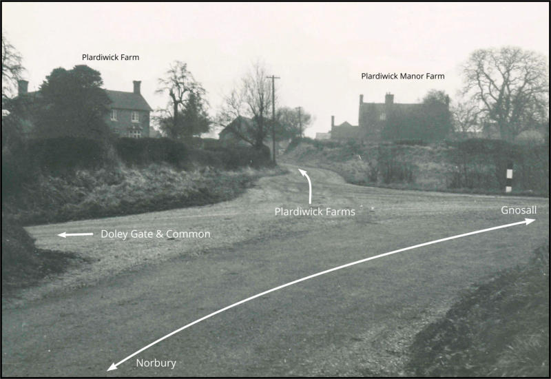
Plardiwick
lies
approximately
half
a
mile
to
the
west
of
Gnosall.
Numerous
spellings
of
its
name
have
been
recorded,
the
ancient
meaning
of
the
former
part
being
'a
place
where
the
right
to
play
games
exists',
'a
sheep
farm'
or
'a
spear
shaft
in
relation
to
the
direction
of
flow
of
a
stream'
with
the
latter
part
of
'wic'
meaning
a
settlement,
village
or
dwelling.
Although
documentary
evidence
of
Plardiwick
before
and
during
medieval
times
is
sparse,
what
is
known
is
that
it
was
an ancient farmstead with lands which were once part of the Manor of High Onn, near Church Eaton.
When
the
Normans
arrived
in
England
after
the
Battle
of
Hastings
they
gave
income
from
land
here
to
their
most
favoured
religious
houses
in
France,
one
of
these
being
the
Benedictine
Abbey
of
St
Evroul,
(having
numerous
spellings),
in
Normandy.
Perhaps
overwhelmed
by
this
extra
responsibility,
the
task
of
managing
these
newly
acquired
English
properties
was
bestowed
upon
the
Prior
of
Ware
in
Hertfordshire.
Records
show
that
the
remit
included
'tenements at Plardiwick'.
The
first
specific
record
of
Plardiwick
is
dated
2nd
October
1199
when
Alured
de
Onne
is
a
defendant
in
a
suit
brought
against
him
by
Osbert
fitz
Orm
and
Alina,
his
wife
concerning
half
a
virgate
of
land
in
Plerdewirke.
(A
virgate
was
the
amount
of
land
tillable
by
two
oxen
in
a
ploughing
season,
equivalent
to
a
quarter
of
a
hide,
so
was
nominally
30
acres.)
Osbert
and
Alina
relinquished
all
claim
to
the
property
for
which
Alured
gave
them
the
sum
of
two
marks,
(£1
6s 8d).
'The
Brough
Family
Organization'
website
informs
how
William
the
Conqueror
bestowed
lands
in
this
area
upon
Baron
Ralph
de
Limesi
from
Normandy.
His
great-grandson
Philip
fitz
Bishop
and
subsequent
family
members
adopted
the
surname
'de
Burgo'
from
the
geographical
area
of
Burgh,
(now
known
as
Brough),
near
Ranton.
A
Hamon
de
Burgo
was
born
at
Ranton
in
1172
and
married
in
Gnosall
in
1192.
His
sons
Bertiline
de
Burgo,
(1193-1252),
Hamon
de
Burgo,
(1205
-
?
)
who
also
used
the
name
Hamon
de
Plerdewicke
and
Michael
de
Burgo
(1209
-
?)
were
all
born
at
Plardiwick.
Records
exist
concerning
an
extraordinary
event
which
definitely
merits
more
detailed
research.
On
6th
October
1268,
a
case
was
brought
to
court
against
Hamon
de
Plerdewicke,
Bertram
de
Burgo,
Robert
de
Knytelegh,
(Knightley),
his
brother
William,
Roger
de
Brunton,
(Brineton
near
Blymhill)
and
others
including
a
priest
from
Gnosall.
All
were
charged
with
trespassing
using
force
and
with
violence
onto
neighbouring
property
in
the
Manor
of
Norbury
belonging
to
Philip
de
Marmion,
5th
Baron
Marmion
of
Tamworth.
The
rebels
demolished
his
house
and
mills,
cut
down
his
trees,
stole
his
timber,
destroyed
his
fishponds
and
caused
other
damage
amounting
to
the
extraordinary
sum
of
£200,
which would equate to over £145,000 today! The defendants did not appear in court.
There
are
references
to
the
existence
of
castellated
and
moated
mansion
at
Plardiwick.
The
name,
'Plardiwick
Hall',
which
may
have
referred
to
the
mansion
existed
as
late
as
1680.
An
interesting
entry
listing
Plardiwick
Hall
as
a
residence appears in the Census of 1861.
In
1393
the
Prior
of
Ware
sued
John
Colet
of
Gnowsale,
(Gnosall),
Henry
Benaster
and
others
the
sum
of
£40,
(which
equates
to
over
£26,000
in
today's
money)
for
forcibly
breaking
into
his
property
at
Plerdewyk
and
letting
their
cattle
tread down his corn and grass.
In
1414
Henry
V
decided
to
suppress
alien
(or
foreign)
priories
and
granted
the
estates
of
St
Evroal's
Priory
administered
at
Ware,
which
included
Plardiwick,
to
the
new
Carthusian
priory
that
he
had
founded
at
Sheen,
near
Richmond
which
became
known
as
the
House
of
Jesus
of
Bethlehem.
The
Prior
of
St
Evroul
wrote
to
protest,
stating
that
this
action
had
caused
him
to
lose
his
chief
source
of
income
and
continued
this
appeal
for
eleven
years,
carrying
the case to Rome, but this was ultimately unsuccessful.
On
3rd
January
1529,
it
is
noted
that
Thomas,
son
and
heir
of
William
Garmeston
was
granted
two
messuages
in
Gnosall,
(a
messuage
being
a
dwelling
house
with
outbuildings
and
land
assigned
to
its
use).
After
his
death
in
1532,
his
son
William
became
his
beneficiary.
In
1543
it
was
recorded
that
William
held
tenure
in
Plardewyk
from
the
Prior
of Sheen valued at 16 shillings.
All
changed
in
the
reign
of
Henry
VIII
with
the
Dissolution
of
the
Monasteries
in
1539.
On
1st
May
1540
the
Manor
of
High
Onn
including
messuages,
lands
and
tenements
at
'Plardwyke',
known
as
a
Lordship
and
held
by
a
John
Blackmare
were
granted
by
the
Crown
to
Sir
John
Giffard
of
Chillington,
(1465
-
1556).
Sir
John
held
prominent
roles
in royal service, including attending the coronation of Henry VIII. He had enjoyed a distinguished military career.
On
Sir
John's
death,
his
property
including
Plardiwick
passed
to
his
son
and
heir,
Sir
Thomas
Giffard,
(1491
-
1560),
who
only
outlived
his
father
by
four
years.
It
was
then
passed
through
the
Giffard
family
to
Edward
Giffard
who
held
documents
recording
the
ownership
of
what
is
described
as
'the
Manor
of
Plardiwick
in
chief
by
military
service',
probably
referring
to
the
deeds
of
Sir
John
Giffard.
Edward
settled
Plardiwick
on
his
second
son,
Thomas
for
a
term
of
ninety-nine
years
at
an
annual
rent
of
20
shillings
in
his
will
dated
1606.
In
1632
John
Giffard,
eldest
son
of
Edward
who
had
been
responsible
for
the
construction
of
Boscobel
House
signed
a
deed
of
covenant
settling
the
Manor
of
'Plordwicke'
on
himself
for
life
and
then
on
his
eldest
daughter
Frances
and
her
heirs.
In
1633
Frances
married
John
Cotton of Giddings Abbotts in Huntingdonshire.
After
the
death
of
her
father,
Frances
Cotton
held
the
manors
of
both
Boscobel
and
Plardiwick.
King
Charles
II
is
reputed
to
have
hidden
in
an
oak
tree
at
Boscobel
House
during
his
escape
following
the
Battle
of
Worcester
in
1651,
but
there
are
no
records
which
suggest
that
Frances
was
living
at
Boscobel
at
the
time.
Some
historians
are
of
the
opinion
that
Plardiwick
may
have
been
considered
as
a
suitable
hiding
place.
When
the
widowed
Frances
passed
away
shortly
after
this
notable
historical
event,
her
property
was
acquired
by
her
daughter
Jane,
who
had
married
Basil
Fitzherbert
of
Swynnerton,
whose
family
were
major
landowners.
Plardiwick
then
descended
through
the
Fitzherbert line.
In
1680,
records
show
that
there
were
six
houses
at
Plardiwick.
When
in
1682,
in
the
organisation
of
Poor
Law
administration,
Gnosall
was
divided
into
four
'Quarters',
Plardiwick
was
included
within
the
Cowley
Quarter
with
Cowley, Coton and Beffcote.
There
are
references
to
a
mill
in
connection
with
Plardiwick.
A
Richard
Ansloe
of
Plardiwick
left
a
mill
to
an
Ann
Beetison
in
1718,
the
reason
not
being
apparent
as
Richard
had
family
heirs.
In
1736
a
father
and
son
named
Forster
sold
a
mill
and
adjoining
land
to
a
Charles
Fitzgerald
of
Warton
for
£50.
This
property
was
leased
to
a
Mr
Calcott
in
1751.
Land
and
a
mill
were
leased
to
a
William
Yeoman
in
1769.
Also
in
this
year,
a
Mr
Calcott
left
the
land
and
mill
to
his granddaughter Elizabeth of Ecclishall.
Dated
1772,
when
Thomas
Fitzherbert
was
Lord
of
the
Manor,
there
exists
detailed
documentation
of
a
'perambulation
of
the
boundaries,
precincts
and
territories
of
the
Manor
of
Plairdiwick'
which
listed
field
names
and
notable
landmarks.
Several fines were subsequently imposed for encroachment and destruction of the game. (see document below).
The
Fitzherbert
family
were
troubled
with
considerable
debt.
An
Act
of
Parliament
in
1789
allowed
the
sale
of
the
Plardiwick
estate
which
then
consisted
of
approximately
320
acres
of
land
and
produced
rents
totalling
£160
from
5
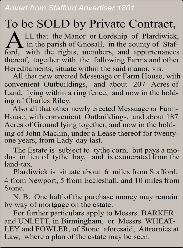
tenants. The purchaser was Thomas Unett of Tittensor, who had descended from another notable family.
Plardiwick
did
not
remain
in
the
Unett
family
for
very
long
as
in
1804
the
Anson
family
of
Shugborough
obtained
the
Plardiwick
Estate
from
the
Unett
family
in
return
for
some
land
at
Hilderstone,
plus
the
sum
of
£1,250.
Thomas
William
Anson,
known
as
Viscount
Anson
and
later
1st
Earl
of
Lichfield
subsequently
held
the
title
of
Lord
of
the
Manor
of
Plardiwick.
The
most
significant
tenants
were
Charles
Riley
and
John
Machin,
inhabiting
farmsteads
described
as
'newly erected' in the sale particulars.
In
1823
The
Willder
family,
who
were
tenants
at
Plardiwick
built
an
Independent
Chapel
at
Coton.
William
Willder
bequeathed
it
to
the
Plymouth
Brethren
in
1866.
It
was
out
of
use
by
1951
and
became
a
shop
in
1953.
The
Willder
family also purchased a steam corn-mill by the Newport Road at Coton..
1826
saw
a
route
variation
of
the
Birmingham
and
Liverpool
Junction
Canal,
built
by
Thomas
Telford,
(later
known
as
the
Shropshire
Union
Canal)
which
crossed
the
Plardiwick
Estate.
This
redesign
was
at
the
insistence
of
Viscount
Anson
as
it
interfered
with
his
pheasant
shooting
rights,
especially
just
past
Plardiwick
approaching
Norbury
at
Shelmore
Wood.
The
diversion
necessitated
problematic
high
embankments
and
deep
cuttings
which
proved
costly
in
terms
of
delay
and
extra
work.
Plardiwick
Bridge,
(36)
formerly
named
Leek
Bridge
after
tenant
William
Leek
and
Barns Bridge (37) were contained within the Plardiwick Estate. The waterway was opened in 1835.
As
a
point
of
interest,
Census
records
show
that
a
Robert
L.
Johnson
occupied
Plardiwick
Farm
in
1881.
His
family
founded the Johnson tile and ceramics works in the Potteries.
In
1911,
Staffordshire
County
Council
acquired
Plardiwick
Farm,
which
consisted
of
the
farmhouse,
three
cottages
and
196
acres
of
land
for
£7,800
for
conversion
into
smallholdings.
My
grandfather
Joseph
Henry
Sumner
was
the
council's
first
tenant
at
Plardiwick
Farm
and
my
father,
Joseph
Godwin
Sumner,
was
born
there
in
1914.
My
grandfather
remained
there
until
Lady
Day
in
1924.
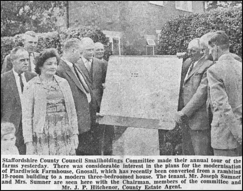
In
1958
my
father
returned
as
tenant.
Much
of
the
rear
part
of
the
farmhouse
was
demolished
in
1964
prior
to
which
it
had
nineteen
rooms
and
thirty-two
windows.
'Joe',
as
he
was
known
remained
there
until
his
retirement
in
1981.
Other
smallholdings
on
the
estate
were
Pear
Tree
Farm,
Barns
Bridge Farm and Coton Wood Farm.
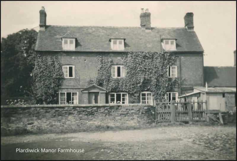
The
200-acre
Plardiwick
Manor
Farm
was
retained
by
the
Lichfield
Estate
until
1970,
latterly
tenanted
by
the
Deakin
family.
It
was
sold
to
Staffordshire
County
Council
for
£47,500.
The
council
decided
to
demolish
the
old
farmhouse
and
build
a
new
house
and
farm
buildings
thereby
creating
a
new
smallholding
to
include
80
acres
of
land
on
a
new
site
with
an
access
road.
The
new
farmstead
was
located
along
the
road
to
Norbury
on
the
opposite
side
to
Barns
Bridge
Farm.
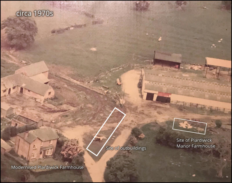
The
demolition
of
the
old
manor
house
took
place
in
1971,
the
resulting
rubble
being
used
to
fill
Plardiwick
Pool
which
was
situated
at
the
end
of
the
drive
shared
by
Plardiwick
Farm
and
Plardiwick
Manor
Farm.
Some local residents have memories of skating on this pool when frozen over during severely cold weather.
My
father
was
allocated
most
of
the
remaining
farm
buildings
formerly
belonging
to
Plardiwick
Manor
Farm
and
further
acreage.
He
was
also
given
the
option
of
taking
on
the
'Plardiwick
Manor
Farm'
name
but
elected
to
stick
with
Plardiwick
Farm
as
he
didn't
want
the
inconvenience
of
notifying
everyone
of
the
change
or
be
burdened
with
writing
the extra word. The new smallholding off the Norbury Road therefore became Plardiwick Manor Farm.
Staffordshire
County
Council
is
currently
in
the
process
of
offering
the
tenants
first
refusal
on
the
purchase
of
their
smallholdings, beginning a new chapter in the history of the Manor of Plardiwick.
Valerie Gough - 2020


A History of the Manor of Plardiwick
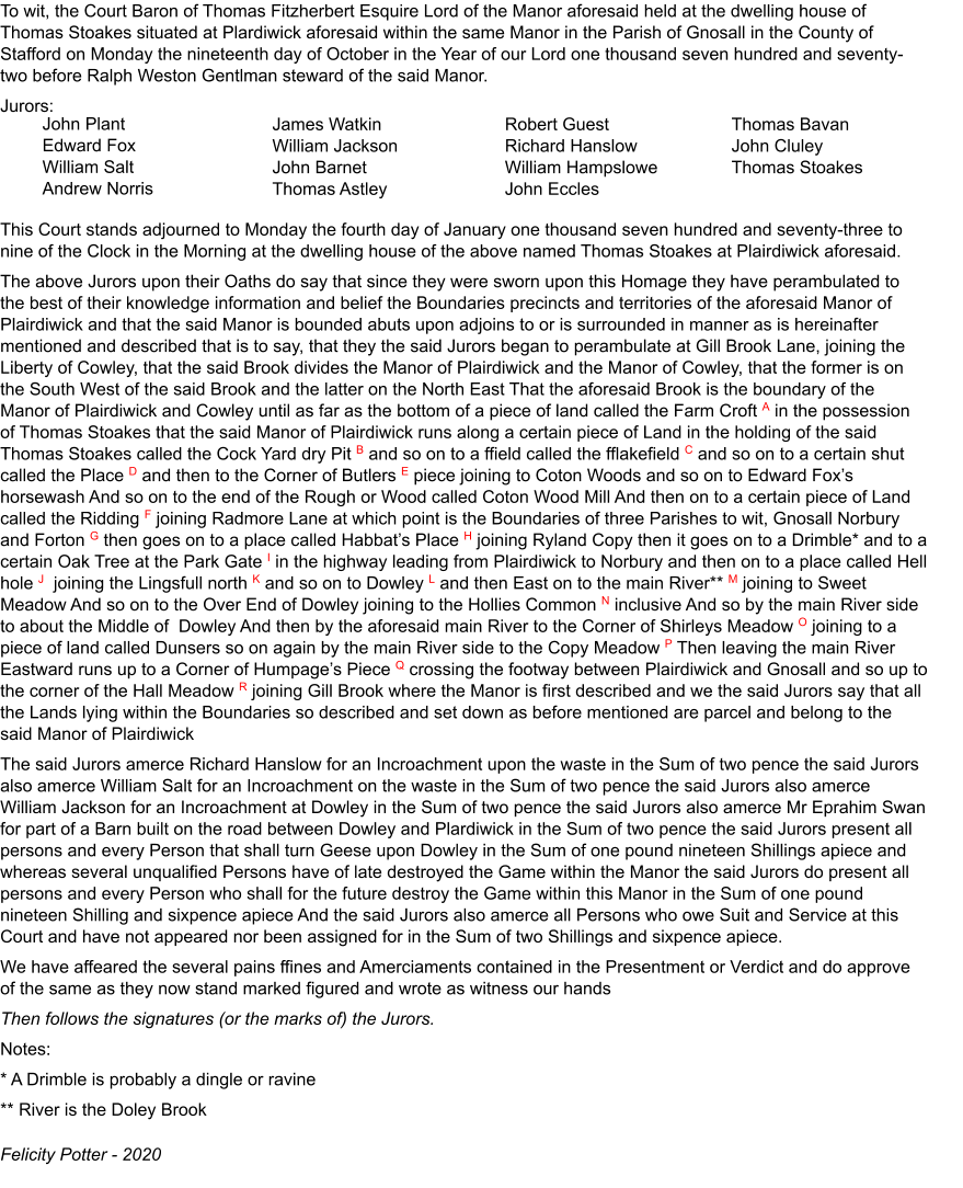
The perambulation of boundaries of Manor of Plardiwick, 1773
On
Monday
19th
October
1772,
twelve
jurors,
presumably
all
local
free
tenants,
met
in
a
Court
Baron
of
Thomas
Fitzherbert,
at
Thomas
Stoakes’s
house
at
Plardiwick,
along
with
Ralph
Weston
who
was
steward
of
the
manor,
John
Cluley (affearer, who assessed fines) and Thomas Stoakes himself.
The
jurors
were
sworn
in
and
the
court
adjourned
until
9am
on
Monday
4th
January
1773,
when
they
again
met
at
Thomas Stoakes’s house, having perambulated and noted the boundaries of Plardiwick Manor.
The
reason
for
organising
this
perambulation,
or
who
initiated
it,
isn’t
known:
there
may
have
been
disputes
and
it’s
interesting
that
some
of
the
jurymen
themselves
were
lightly
fined
for
encroachments,
mainly
in
the
Doley
direction.
There
had
been
also
poaching
within
the
manor
and
geese
pastured
on
Doley
Common,
and
there
were
much
heavier
fines
for
these.
(There
had
been
a
series
of
anti-poaching
acts
through
the
18th
century,
and
the
Gnosall
Association
for
the
Prosecution
of
Felons
was
set
up
in
1795.)
Finally
any
tenants
who
should
have
turned
up,
and
hadn’t, were to be fined. (Courts Baron dated back to medieval times and attendance then was compulsory.)
Alternatively Fitzherbert may have been thinking of selling and wanted to be clear where the boundaries were.
Many
of
the
field
shapes
on
the
map,
and
field
names
from
Mr
Smith's
documents,
match
those
on
the
1837
Tithe
Map which made tracing the route a great deal easier!
There are two puzzles near the beginning of the perambulation description:
•
it reverses the compass directions of Plardiwick and Cowley - this must be a mistake;
•
and
it
refers
to
a
stream,
Gill
Brook.
The
perambulation
route
begins
by
following
this
brook,
which
is
also
the
boundary
with
Cowley.
Study
of
water
sources
and
gradient
indicates
that
the
brook
referred
to
arose
at
the
Coton
watershed
and
flowed
east
into
Doley
Brook
(and
indeed
still
does),
but
was
culverted
under
the
canal
1830
and
railway 1840. Gill Brook Lane no longer exists (see Research Notes).
•
Superscript characters within the transcription refer to the map below
Explanation of document
Document Transcript
Plardiwick maps over time
A number of maps and plans have been digitised and can be seen by clicking the brown button on the left hand
side.
These show outline of the Manor of Plardiwick in 1773, - 1795, - 1813,- 1838, - 1880, - 1910
Any annotation is based on knowledge gratefully received from researchers. If you wish to comment or
provide additional material then please email me at the link on the Gnosall History home page.
Plardiwick photographs
Click on any image to enlarge
Research notes

Researchers: Valerie Gough, Felicity Potter, Mike Barton, Mary Booth, Bob Johnson
The research into the Manor of Plardiwick was helped by resources at Stafford Record Office, Ronald Smith's
numerous documents, and old maps for which we acknowledge and are very grateful. Also by extensive on-site
investigation.
The documenting of the perambulation of the Manor of Plardiwick boundary in 1773 raised a few questions. Near the
beginning of the document it mentions Gill Brook and Gill Brook Lane, neither of which are named on current maps.
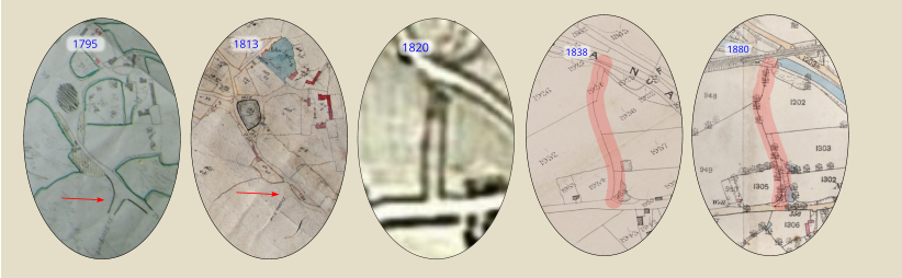
Gill Brook Lane
The 1795 map shows a road ‘To Newport’ (see red arrow on map extract). Because this couldn’t be matched to any
current roads it was initially thought the cartographer had foreshortened the turning onto the main A518 road through
Gnosall towards Newport.
However, this same turning is shown on the 1813 map, and is sign posted ‘To Coton End’. In addition the Greenwood
1820 map shows the full extent of a lane.
So it appears that the 1795, 1813 and 1820 cartographers were correct, but what happened to the lane?
The 1838 Tithe map shows that the building of the Birmingham-Liverpool canal had blocked off the lane except for a
small strip of land (plot 1924) in the same location, described as ‘Part of Leeks Meadow (old lane)’. So it had been put
back to agricultural use. This is probably ‘Gill Brook Lane’
Then on the 1880 OS. a dotted line to the left of field Nos. 1302 and 1303 suggests some kind of path.
Therefore it is concluded that the line in red shown on the maps here is the route of Gill Brook Lane.
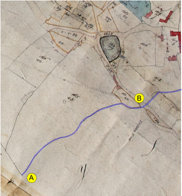
Gill Brook
The perambulation text indicates the closeness of Gill Brook to Gill Brook Lane. Searching for “Gill Brook” on the
internet suggested that the origination of the name ‘Gill’ might have been derived from the ‘Guild of Monks’, a farm
located to the west of Gnosall close to Humesford Brook which
flows westwards into Aqualate Mere; and that particular
watercourse was Gill Brook which was later renamed
Humesford Brook.
Our research shows this not to be the case.
However, the building of both the canal and railway and the
lowering of the water table by increased water abstraction has
almost hidden the original route of a stream rising at point ‘A’’ on
this 1813 map and flowing to point ‘B’, a fall of about 6 metres.
The stream finally discharges into the Doley Brook outside of
the Manor of Plardiwick boundary.
Substantial research using old maps and on-site investigations
leads the researchers to conclude that this is Gill Brook as
mentioned in the perambulation document.
As can be seen on the map it did meet up with Gill Brook Lane
at point ‘B’.
It's worth noting that part of the course of Gill Brook was used as the boundary between the Gnosall and the Cowley
1838 Tithe Maps.

Click above for home screen